Arrival
Kathmandu to Unknown finish
Arrival in Kathmandu, transfer to your hotel or our guesthouse.
The Mansalu Circuit trek is one of finest treks in Nepal, quite remote and offering culture, scenery and great walking.
Save it for later or mark it as completed to improve your dashboard recommendations.
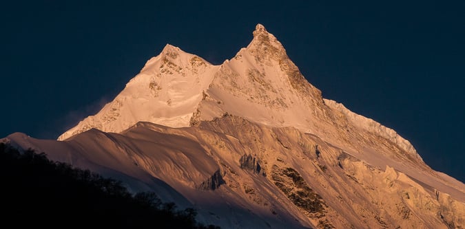
The drive from Kathmandu to Machikhola takes around 8 hours and the return drive from Besisahar to Kathmandu takes around 7 hours. The trek ascent is for 9 days, which includes two full days rest / acclimatisation which stay at the same overnight village, to the last settlement. After one day climbing up and over the high point of Larkya La at 5160m with excellent panoramic views of Himlung Himal, Cheo Himal, Kang Guru and Annapurna II, the descent is then another 3 days.
The Mansalu Circuit trek is one of finest treks in Nepal, quite remote and offering culture, scenery and great walking. The drive from Kathmandu to Machikhola takes around 8 hours and the return drive from Besisahar to Kathmandu takes around 7 hours. The trek ascent is for 9 days, which includes two full days rest / acclimatisation which stay at the same overnight village, to the last settlement. After one day climbing up and over the high point of Larkya La at 5160m with excellent panoramic views of Himlung Himal, Cheo Himal, Kang Guru and Annapurna II, the descent is then another 3 days.
- 18-day sourced itinerary - High point around 5160 metres - Approximate route distance of 190 km - Peak focus: Manaslu - Key locations: Kathmandu, Kathmandu, Machha Khola, Samagaun
Kathmandu to Unknown finish
Arrival in Kathmandu, transfer to your hotel or our guesthouse.
Kathmandu to Unknown finish
Rest day and possibility of a sightseeing tour if you would like to see around Kathmandu. Trek briefing.
Kathmandu to Unknown finish
We will leave Kathmandu in the early morning for a 7 / 8 hr drive to Machha Khola where the Manaslu region treks begin. It is around 160 kilometres from Nepal’s capital to this small village location. If you’re traveling by private vehicle from Kathmandu to Machha Khola, it takes roughly 6 to 8 hours. Taking a public transportation vehicle to Machha Khola takes approximately eight to ten hours. Machha Khola is located approximately 870 meters (2,854 feet) above sea level. The road to Machha Khola is in reasonable condition but it can, depending on local conditions have occasional off-road sections. Previously, Arughat was the starting point for the Manaslu Trek or Tsum Valley Trek, however recent road construction has made it possible to travel to further to Machha Khola.
Kathmandu to Unknown finish
This morning we ease into our trek by leaving Machha Khola and soon reach Khorlabesi, where there is a small natural hot spring. After an uphill section we’ll then cross the Budi Gandaki via a suspension bridge. Today’s trail takes us through forests, along ridges with great views and undulates until we reach our destination and home for the night at the village of Jagat
Kathmandu to Unknown finish
The trek from Jagat to Pewa is a scenic and moderately challenging section of the Manaslu Circuit Trek. This stretch takes you through beautiful landscapes, suspension bridges, rivers, and traditional villages. The trail from Jagat to Pewa is well-marked, mix of stone-paved paths, forest trails, and suspension bridges. We start from the beautiful stone built village of Jagat (1,340m) and trek uphill towards Salleri and Sirdibas, passing small settlements with terraced fields, with beautiful views of the Budhi Gandaki River below. After hiking from Sirdibas we can see the large Gurung village with chortens and prayer flags at Philim (1,570m). It is also the same route to the Tsum Valley junction. After Philim, the trail descends and climbs again through forests and passes Ekle Bhatti, a small rest stop with basic lodges. The trail then becomes narrow but still has scenic views across to the waterfalls. After crossing a long suspension bridge over the Budhi Gandaki River we enter a dense rhododendron and bamboo forests. We venture through the forest finally reaching Pewa, which is a quaint, peaceful village with a few teahouses and an ideal place to stay overnight.
Kathmandu to Unknown finish
This section of the Manaslu Circuit Trek takes you through dense forests, stunning waterfalls, and traditional Tibetan-influenced villages. The altitude gradually increases, and the scenery becomes more dramatic. From Pewa to Ghap the trek begins with a scenic walk through bamboo and rhododendron forests. We need to Cross two suspension bridges over the Budhi Gandaki River before arriving at Deng, a small village with a few teahouses. From Deng the views of Siringi Himal (7,161m) are spectacular. After a short ascent to Rana village, the trail continues along forested ridges with occasional steep sections. We then pass through the small settlement of Bihi Phedi with beautiful Mani walls and Prayer Wheels. The trail then follows an undulating path along the river and next to more lush forests. After crossing multiple wooden and metal suspension bridges we finally reach our destination of Ghap, which is a charming traditional village with Mani Walls and Chortens.
Kathmandu to Unknown finish
Today is a shorter day with this section of the Manaslu Circuit Trek taking us through dense forests, traditional Buddhist villages, and increasing altitudes with stunning views of the surrounding Himalayas. The trek is a gradual but a steady ascent, offering a mix of scenic beauty and cultural experiences. From Ghap to Prok (2,580m), the trail follows a dense pine and rhododendron forest, with occasional steep sections. We agina cross multiple suspension bridges over the Budhi Gandaki River. There is an option for a side trek to Prok village, which offers amazing views of Siringi Himal (7,161m). From Prok to Namrung (3,180m), the trail gradually ascends through forests filled with mossy trees and waterfalls. We pass many Mani Walls, Chortens, and Prayer flags, signalling a strong Tibetan Buddhist influence in this region. The last section involves a steep climb on stone steps before reaching Namrung. Namrung is a well-developed village with a Tibetan culture, traditional houses and monasteries. The village also has a number of tea houses, bakeries, and good accommodation options. From here we have stunning views of Ganesh Himal, Himal Chuli, and Siringi Himal.
Kathmandu to Unknown finish
This is one of the most scenic sections of the Manaslu Circuit Trek, offering breathtaking views of snow-capped peaks as you enter the high Himalayan region. The trail takes you through traditional Tibetan villages, monasteries, and expansive alpine landscapes. From Namrung to Lihi (2,900m), we begin with a gentle climb past Mani walls and Chortens until we will reach Lihi, a small Tibetan-style village with barley fields and monasteries. From this point we will should have clear views of Manaslu, Himal Chuli and Ganesh Himal. From Lihi to Lho (3,180m), the trail descends slightly before climbing up through pine forests. We arrive at Lho, a beautiful village with a large Ribung Monastery and stunning views of Manaslu (8,163m). This is a great place for a tea break and monastery visit. From Lho to Shyala (3,520m),the trail ascends gradually, passing through dense forests and yak pastures. We arrive in Shyala, a wide-open valley surrounded by towering peaks with more incredible views of Manaslu, Himal Chuli, Ngadi Chuli, and Peak 29. The 360-degree mountain views make it a perfect place to rest overnight before heading to Samagaun.
Kathmandu to Unknown finish
This is a short day but an incredibly scenic section of the Manaslu Circuit Trek, bringing you closer to Mount Manaslu (8,163m). The trail passes through open valleys, yak pastures, and traditional Tibetan settlements, offering breathtaking Himalayan views. From Shyala to Samagaun (3,530m), we initially start with a gentle descent through a wide-open glacial valley, again crossing wooden bridges over small streams formed by melting glaciers. As we walk through yak pastures with incredible views of Manaslu, Himal Chuli, and Ngadi Chuli again passing numerous traditional Chortens, Mani Walls, and small Prayer Wheels that mark the entrance to Samagaun. Samagaun is one of the biggest villages on the Manaslu Circuit, heavily influenced by Tibetan culture. Houses in Samagaun are built in traditional stone architecture and locals wear Tibetan-style clothing. We will have amazing views of Manaslu (8,163m) towering directly above the village.
Kathmandu to Unknown finish
At these higher altitudes it is necessary to rest and spend a bit of time at the same height, or walk and bit higher and return to our overnight height to aid our acclimatisation, and before attempting climbs to higher altitudes. You can rest or there are options for some activity, such as exploring the Gompa at Pugyen (4070m), a one day hike that leaves the trail between Syaula and Sama. If time permits, it is possible for you to carry on up this valley to the rugged rocks and terrain of the Pugin glacier. Another option is a trip to the lake at Birendra Tal (3450m) or a demanding ascent to Manaslu Base Camp (4900m). It is believed that north of Birendra Tal is Milarepa’s Cave (famous Buddha) claimed to have been used as a meditation retreat by the Buddhist saint.
Kathmandu to Unknown finish
This section of the Manaslu Circuit Trek is a short but but also another step towards good acclimatisation for our journey ahead we we ascend further into the high-altitude region. The landscape becomes more barren and rugged, with fewer trees and more open valleys as we approach the remote Tibetan-influenced village of Samdo. From Samagaun to the Budhi Gandaki River (3,700m), the trail follows a gentle climb out of Samagaun. We then cross the Birendra Lake junction with the Manaslu Glacier to our left. We then continue along a wide valley with small yak pastures and scattered chortens and cross the Budhi Gandaki River via a wooden bridge. From Budhi Gandaki to Samdo (3,890m) the trail ascends gradually along a barren, rocky landscape. If we are lucky enough we may see blue sheep and Himalayan Marmots along the way. We will soon see Samdo come into view, which is a remote village just 4 km from the Tibetan border and our destination for the day.
Kathmandu to Unknown finish
Samdo (3,890m) is at high altitude, so spending an extra day for acclimatisation is crucial before heading toward Dharamsala (Larke Phedi) and Larke Pass (5,106m). This rest day helps prevent altitude sickness and prepares your body for the higher elevations ahead. We can go on some local walks or relax such as: Hike to the Tibet Border Viewpoint (~5,000m) – 5/6hrs – this is the old trade route to Tibet, used by locals for centuries. It offers breath taking views of the Tibetan plateau, Samdo Glacier, and Mount Manaslu. There is a high chance of spotting blue sheep, Himalayan eagles, and even snow leopards. Hike to Samdo Ridge (~4,500m) – 3hrs – Amazing panoramic views of Manaslu (8,163m), Samdo Peak, and Dharamsala. This is a less strenuous option than the Tibet Border hike but still beneficial for acclimatisation. Great photography spot for sunrise or sunset. Or, stay local and explore Samdo Village & Monastery – experience Tibetan culture, visit a small monastery and interact with locals. Watch the traditional yak herding and admire the Tibetan-style stone houses.
Kathmandu to Unknown finish
Today we again gain altitude as we prepare for the crossing of the Larke Pass (5,106m) the next day. The trail becomes more barren and rugged, with stunning views of snow-covered peaks and glaciers. From Samdo to Larke River Crossing (4,200m), the trail starts with a gentle climb through rocky meadows and yak pastures. We again cross small wooden bridges over the Larke River which reflect magificent views of Manaslu and Samdo Peak. The surrounding glaciers are even more spectacular as we climb. From Larke River to Dharamshala (4,460m) the trail gradually ascends over glacial moraines and rocky slopes. All being well we’ll continue to spot blue sheep and Himalayan marmots along the barren landscape. We soon arrive at Dharamsala (Larke Phedi) which is a small seasonal settlement with basic but comfortable accommodation.
Kathmandu to Unknown finish
This is the most challenging and rewarding day of the Manaslu Circuit Trek! We have prepared well in terms or our acclimatisation as today we cross the Larke La Pass (5,106m), the highest point of our trek. The climb is demanding but the panoramic views of Himalayan giants make it an unforgettable experience. After reaching the pass you descend into the beautiful alpine valley of Bimthang (3,720m). From Dharamsala to Larke Pass (5,106m) takes about 3-5 hours. We will start early in the morning (around 3-4 am) to cross the pass before the afternoon winds arrive. The climb is gradual but long with rocky and glacial moraines under foot. As you ascend the view of the Larke Glacier and surrounding peaks is stunning. The final section to the pass is steep and challenging and often covered in snow. After reaching Larke Pass (5,106m) we are treated to incredible views of Manaslu (8,163m), Himlung Himal (7,126m), Kang Guru (6,981m), and Annapurna II (7,937m). Prayer flags and Chortens mark the highest point of the trek. From Larke Pass to Bimthang (3,720m) is a further 4-5 hours. The descent is long and steep, requiring careful footing on loose scree and occasionally icy patches. We pass through a rugged glacial valley with huge icefalls and rocky moraines. As we descend the landscape transitions from barren high-altitude terrain to lush alpine meadows before finally entering Bimthang (3,720m), which is located in a stunning valley surrounded by snow-capped peaks.
Kathmandu to Unknown finish
Today we continue our descent and in addition to the valley and trees below, we also have fantastic views of Manaslu, Lamjung Himal, Himlung Himal, and Cheo Himal throughout the day. Our trail takes us through the the town of Karche (2785m), which is the highest farming point in the area, and crosses the Dudh Khola river. We also pass through rhododendron trees before reaching Gho Village for a quick respite. We then continue to Tiliche (2300m) for the night.
Kathmandu to Unknown finish
The trail today follows a rocky path along the Dudh Khola river past Mani stones until we reach Thonje Village. We pass through a police checkpoint and then head to Dharapani at which point we connect with the main Annapurna trail. From Dharapani we will take a Jeep to Besisahar a journey of about 4 hours. Our last night of trek is then spent at Besisahar and right out of altitude at 760M.
Kathmandu to Unknown finish
Today we drive back to Kathmandu. It’s a scenic drive and strange, after the mountains to be amongst daily life again. After 6/7 hours we will reach Kathmandu and will drop you off at your hotel.
Kathmandu to Kathmandu
If our itinerary runs as planned this can be your departure or onward travel day. However, trekking in these regions can be impacted by inclement weather conditions or internal travel delays. Therefore we recommend allowing yourself an extra day to facilitate any delays, and if it’s not needed, you can relax and enjoy the bustling and vibrant sights of Kathmandu on a city tour.
Peaks at or above 6000 metres.