Day 1
Arrival
Arrival. Expect moderate difficulty.
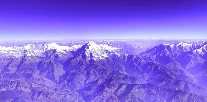
North and South Base Camps Kanchenjunga Trek Guided Itinerary is the 25-day option for North and South Base Camps Kanchenjunga Trek. It is graded moderate and reaches about 5,388 metres. The itinerary follows a guided format with day-to-day timing adjusted to conditions, travel logistics, and acclimatisation needs.
North and South Base Camps Kanchenjunga Trek Guided Itinerary is the 25-day option for North and South Base Camps Kanchenjunga Trek. It is graded moderate and reaches about 5,388 metres. The itinerary follows a guided format with day-to-day timing adjusted to conditions, travel logistics, and acclimatisation needs.
Stay style: Accommodation follows the standard overnight pattern for this route, with exact properties confirmed closer to departure.
Food and support: Meals usually follow the standard route pattern, with lodge, camp, or trail food depending on the stage.
Arrival. Expect moderate difficulty.
This stage covers Stage based from Kathmandu. Expect moderate difficulty.
This stage covers Kathmandu – Bradrapur, Taplejung. Expect moderate difficulty, a high point near 1,820 metres. Typical moving time is around 8.8 hours.
This stage covers Taplejung, Sekathum (Sukethum). Expect moderate difficulty, about 0 metres of ascent, about 244 metres of descent, a high point near 1,576 metres. Typical moving time is around 6 hours.
This stage covers Sekathum – Amjilossa. Expect moderate difficulty, about 732 metres of ascent, about 0 metres of descent, a high point near 2,308 metres. Typical moving time is around 7 hours.
This stage covers Amjilossa – Gybala. Expect moderate difficulty, about 422 metres of ascent, about 0 metres of descent, a high point near 2,730 metres. Typical moving time is around 8 hours.
This stage covers Gybala, Ghunsa. Expect moderate difficulty, about 865 metres of ascent, about 0 metres of descent, a high point near 3,595 metres. Typical moving time is around 6 hours.
Ghunsa acclimatisation day and walk to the view point is used as a rest and acclimatisation day. Base altitude or local high point is around 3,595 metres. Short local walks may be used if conditions and energy levels allow.
This stage covers Ghunsa to Khambachen. Expect moderate difficulty, about 455 metres of ascent, about 0 metres of descent, a high point near 4,050 metres. Typical moving time is around 6 hours.
This stage covers Khambachen, acclimatise with a trek to Janu View Point (Kumbhakarna Base Camp). Expect moderate difficulty, about 509 metres of ascent, about 0 metres of descent, a high point near 4,559 metres. Typical moving time is around 4 hours.
This stage covers Khambachen, Lhonak. Expect moderate difficulty, about 221 metres of ascent, about 0 metres of descent, a high point near 4,780 metres. Typical moving time is around 5 hours.
This stage covers Lhonak – Pangpema (Kanchenjunga north side base camp). Expect moderate difficulty, about 363 metres of ascent, about 0 metres of descent, a high point near 5,143 metres. Typical moving time is around 3 hours.
This stage covers Pangpema, half day hike and then drop back to Lhonak. Expect moderate difficulty, about 0 metres of ascent, about 363 metres of descent, a high point near 4,780 metres. Typical moving time is around 7 hours.
Following back along the same path for around 4 hours.
Following back along the same path for around 4 hours.
From Ghunsa, the trail climbs steeply 500m to the high camp, for an overnight stay in preparation for the trek to Mirgin La Pass.
This stage covers High Camp – Mirgin La Pass 4663m – Tseram. Expect moderate difficulty, about 0 metres of ascent, about 330 metres of descent, a high point near 3,870 metres. Typical moving time is around 6 hours.
This stage covers Tseram – Ramche. Expect moderate difficulty, about 710 metres of ascent, about 0 metres of descent, a high point near 4,580 metres. Typical moving time is around 3 hours.
This stage covers Day trek to Oktang (Kanchenjunga South Base Camp). Expect moderate difficulty, about 150 metres of ascent, about 0 metres of descent, a high point near 4,730 metres. Typical moving time is around 5 hours.
This stage covers Ramche – Tortong. Expect moderate difficulty, about 0 metres of ascent, about 1,735 metres of descent, a high point near 2,995 metres. Typical moving time is around 7 hours.
This stage covers Tortong – Yamphudin. Expect moderate difficulty, about 0 metres of ascent, about 915 metres of descent, a high point near 2,080 metres. Typical moving time is around 8 hours.
This stage covers Yamphudin – Mamanke. Expect moderate difficulty, about 0 metres of ascent, about 295 metres of descent, a high point near 1,785 metres. Typical moving time is around 7 hours.
Drive from Mamanke, Kanyam. Expect moderate difficulty, about 0 metres of ascent, about 343 metres of descent, a high point near 1,442 metres. Typical moving time is around 8 hours.
Drive to Bhadrapur, fly to Kathmandu. Expect moderate difficulty. Typical moving time is around 9.8 hours.
Rest day in Kathmandu, explore the city or possible onward travel is used as a rest and acclimatisation day. Short local walks may be used if conditions and energy levels allow.
Fly home on an am or pm flight.