Margherita Peak
Uganda · Rwenzori
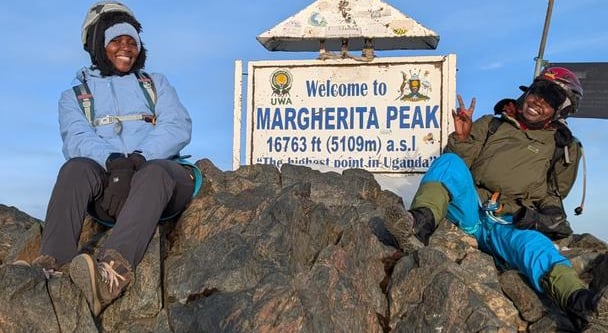
The summit objective on Mount Stanley and the highest point reached on the Rwanda/Uganda itinerary.
Track this summit
Add it to your wish list or tick it off once you have climbed it to update your peak-bagging dashboard.
What to expect on this mountain
The summit objective on Mount Stanley and the highest point reached on the Rwanda/Uganda itinerary.
Summit-day hazards include cold exposure, altitude, slippery rock, and glacier or snow travel depending on current conditions.
Airports
Photos from Margherita Peak
Guided summit options for Margherita Peak
These guided itineraries explicitly include a summit of Margherita Peak.
Rwanda Uganda Volcanoes and Rwenzori Fourteen Day
A serious East Africa mountain itinerary that stacks one volcano day, one two-day volcano expedition, gorilla tracking, and a full high mountain summit push.
Support style: Local guides, ranger teams, and full porter support in the Rwenzori
Nearby itineraries and route styles
These itineraries are relevant to the area and base logistics. Some do not include a summit of Margherita Peak.
Routes for Margherita Peak and nearby objectives
Margherita Peak Central Circuit Route
Summit-focused progression from the Nyakalengija approach through the upper basin to Margherita Peak and back out.
Access notes: Nyakalengija is identified as the trailhead near Kasese and is the local access point for approaches into the Rwenzori. The route follows the access pattern used for Rwenzori treks and the Central Circuit approach to Margherita Peak.
Rwenzori High Peaks Traverse
A circuit of the Rwenzori Range that links the primary Uganda-side access route with extensions toward the range's principal high summits.