Day 1
Arrival
Arrival. Expect moderate difficulty, a high point near 1,400 metres.
18-day trekking itinerary, reaching about 5,160 metres
Save it for later or mark it as completed to improve your dashboard recommendations.
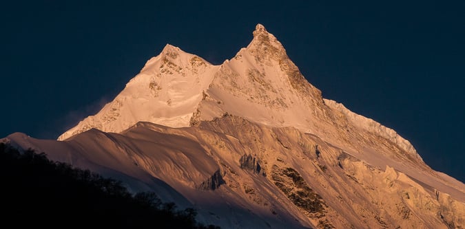
The drive from Kathmandu to Machikhola takes around 8 hours and the return drive from Besisahar to Kathmandu takes around 7 hours. The trek ascent is for 9 days, which includes two full days rest / acclimatisation which stay at the same overnight village, to the last settlement. After one day climbing up and over the high point of Larkya La at 5160m with excellent panoramic views of Himlung Himal, Cheo Himal, Kang Guru and Annapurna II, the descent is then another 3 days.
Manaslu Circuit Trek is a trekking itinerary running over 18 days with a high point around 5,160 metres and a moderate grading. Typical routing includes Kathmandu, Machha Khola, Samagaun.
- 18-day sourced itinerary - High point around 5160 metres - Approximate route distance of 190 km - Peak focus: Manaslu - Key locations: Kathmandu, Kathmandu, Machha Khola, Samagaun
Arrival. Expect moderate difficulty, a high point near 1,400 metres.
Preparation / rest day / sightseeing is used as a rest and acclimatisation day. Base altitude or local high point is around 1,400 metres. Short local walks may be used if conditions and energy levels allow.
This stage covers Kathmandu to Machha Khola. Expect moderate difficulty, about 0 metres of ascent, about 530 metres of descent, a high point near 870 metres. Typical moving time is around 8 hours.
This stage covers Machha Khola, Jaget. Expect moderate difficulty, about 470 metres of ascent, about 0 metres of descent, a high point near 1,340 metres. Typical moving time is around 7 hours.
This stage covers Stage based from Kathmandu. Expect moderate difficulty, about 520 metres of ascent, about 0 metres of descent, a high point near 1,860 metres. Typical moving time is around 7 hours.
This stage covers Stage based from Kathmandu. Expect moderate difficulty, about 520 metres of ascent, about 0 metres of descent, a high point near 2,380 metres. Typical moving time is around 6 hours.
This stage covers Ghap, Namrung. Expect moderate difficulty, about 800 metres of ascent, about 0 metres of descent, a high point near 3,180 metres. Typical moving time is around 4 hours.
This stage covers Namrung, Shyala. Expect moderate difficulty, about 340 metres of ascent, about 0 metres of descent, a high point near 3,520 metres. Typical moving time is around 7 hours.
This stage covers Shyala, Samagaun. Expect moderate difficulty, about 10 metres of ascent, about 0 metres of descent, a high point near 3,530 metres. Typical moving time is around 3 hours.
Samagaon – Rest and acclimatisation day is used as a rest and acclimatisation day. Base altitude or local high point is around 4,200 metres. Short local walks may be used if conditions and energy levels allow.
This stage covers Samagaon, Samdo. Expect moderate difficulty, about 0 metres of ascent, about 310 metres of descent, a high point near 3,890 metres. Typical moving time is around 3 hours.
Samdo – acclimatisation day is used as a rest and acclimatisation day. Base altitude or local high point is around 3,890 metres. Short local walks may be used if conditions and energy levels allow.
This stage covers Samdo, Dharmashala. Expect moderate difficulty, about 570 metres of ascent, about 0 metres of descent, a high point near 4,460 metres. Typical moving time is around 5 hours.
This stage covers Dharmasala to Bimthang via Larke pass ( 5106m). Expect moderate difficulty, about 646 metres of ascent, about 0 metres of descent, a high point near 5,106 metres. Typical moving time is around 11 hours.
This stage covers Bimthang, Tiliche. Expect moderate difficulty, about 0 metres of ascent, about 2,806 metres of descent, a high point near 2,300 metres. Typical moving time is around 7 hours.
This stage covers Tiliche, Besisahar. Expect moderate difficulty, about 0 metres of ascent, about 1,540 metres of descent, a high point near 760 metres. Typical moving time is around 4 hours.
Drive back to Kathmandu. Expect moderate difficulty, about 640 metres of ascent, about 0 metres of descent, a high point near 1,400 metres. Typical moving time is around 7 hours.
This stage covers Day activity based around Kathmandu. Expect moderate difficulty.
Peaks at or above 6000 metres.