Day 1
Arrival
Arrival. Expect moderate difficulty, a high point near 1,400 metres.
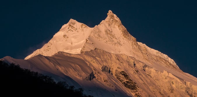
Manaslu Circuit Trek Guided Itinerary is the 18-day option for Manaslu Circuit Trek. It is graded moderate and reaches about 5,160 metres. The itinerary follows a guided format with day-to-day timing adjusted to conditions, travel logistics, and acclimatisation needs.
Manaslu Circuit Trek Guided Itinerary is the 18-day option for Manaslu Circuit Trek. It is graded moderate and reaches about 5,160 metres. The itinerary follows a guided format with day-to-day timing adjusted to conditions, travel logistics, and acclimatisation needs.
Stay style: Accommodation follows the standard overnight pattern for this route, with exact properties confirmed closer to departure.
Food and support: Meals usually follow the standard route pattern, with lodge, camp, or trail food depending on the stage.
Arrival. Expect moderate difficulty, a high point near 1,400 metres.
Preparation / rest day / sightseeing is used as a rest and acclimatisation day. Base altitude or local high point is around 1,400 metres. Short local walks may be used if conditions and energy levels allow.
This stage covers Kathmandu to Machha Khola. Expect moderate difficulty, about 0 metres of ascent, about 530 metres of descent, a high point near 870 metres. Typical moving time is around 8 hours.
This stage covers Machha Khola, Jaget. Expect moderate difficulty, about 470 metres of ascent, about 0 metres of descent, a high point near 1,340 metres. Typical moving time is around 7 hours.
This stage covers Stage based from Kathmandu. Expect moderate difficulty, about 520 metres of ascent, about 0 metres of descent, a high point near 1,860 metres. Typical moving time is around 7 hours.
This stage covers Stage based from Kathmandu. Expect moderate difficulty, about 520 metres of ascent, about 0 metres of descent, a high point near 2,380 metres. Typical moving time is around 6 hours.
This stage covers Ghap, Namrung. Expect moderate difficulty, about 800 metres of ascent, about 0 metres of descent, a high point near 3,180 metres. Typical moving time is around 4 hours.
This stage covers Namrung, Shyala. Expect moderate difficulty, about 340 metres of ascent, about 0 metres of descent, a high point near 3,520 metres. Typical moving time is around 7 hours.
This stage covers Shyala, Samagaun. Expect moderate difficulty, about 10 metres of ascent, about 0 metres of descent, a high point near 3,530 metres. Typical moving time is around 3 hours.
Samagaon – Rest and acclimatisation day is used as a rest and acclimatisation day. Base altitude or local high point is around 4,200 metres. Short local walks may be used if conditions and energy levels allow.
This stage covers Samagaon, Samdo. Expect moderate difficulty, about 0 metres of ascent, about 310 metres of descent, a high point near 3,890 metres. Typical moving time is around 3 hours.
Samdo – acclimatisation day is used as a rest and acclimatisation day. Base altitude or local high point is around 3,890 metres. Short local walks may be used if conditions and energy levels allow.
This stage covers Samdo, Dharmashala. Expect moderate difficulty, about 570 metres of ascent, about 0 metres of descent, a high point near 4,460 metres. Typical moving time is around 5 hours.
This stage covers Dharmasala to Bimthang via Larke pass ( 5106m). Expect moderate difficulty, about 646 metres of ascent, about 0 metres of descent, a high point near 5,106 metres. Typical moving time is around 11 hours.
This stage covers Bimthang, Tiliche. Expect moderate difficulty, about 0 metres of ascent, about 2,806 metres of descent, a high point near 2,300 metres. Typical moving time is around 7 hours.
This stage covers Tiliche, Besisahar. Expect moderate difficulty, about 0 metres of ascent, about 1,540 metres of descent, a high point near 760 metres. Typical moving time is around 4 hours.
Drive back to Kathmandu. Expect moderate difficulty, about 640 metres of ascent, about 0 metres of descent, a high point near 1,400 metres. Typical moving time is around 7 hours.
This stage covers Day activity based around Kathmandu. Expect moderate difficulty.