Margherita Peak Expedition
A summit-focused Rwenzori climb to Margherita Peak with a porter-supported mountain team.
- Difficulty
- Severe
- Duration
- 6 days
- Region
- Rwenzori
Uganda's high mountain range, used for the Margherita Peak summit expedition and supporting acclimatisation stages.


A summit-focused Rwenzori climb to Margherita Peak with a porter-supported mountain team.
A dedicated Rwenzori ascent to one of the range's major summits.
A summit-first Rwenzori expedition centred on Uganda's highest mountain block.
A longer Rwenzori expedition built around the strongest Uganda-side high peaks.
A serious hut-to-hut mountain trek in Uganda's highest range.
A shorter Rwenzori mountain break built around the Uganda trailhead and lower circuit.
Uganda's two biggest mountain signatures in one itinerary.
Use these route-linked adventures to plan the trails and traverses that sit inside this region.
Summit-focused progression from the Nyakalengija approach through the upper basin to Margherita Peak and back out.
Summit route in the Rwenzori Mountains that ascends Mount Speke via the Uganda Central Circuit.
A circuit of the Rwenzori Range that links the primary Uganda-side access route with extensions toward the range's principal high summits.
Supporting planning details for where trips start, finish, or stay overnight in this region.
Main logistics town for the Uganda side of the trip and the Rwenzori exit point.
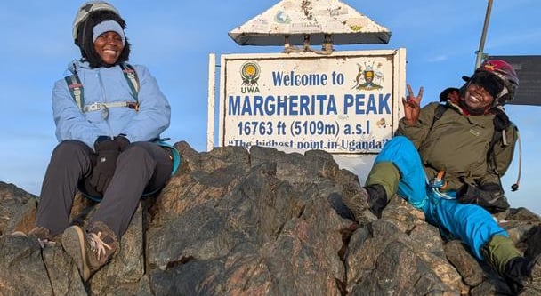
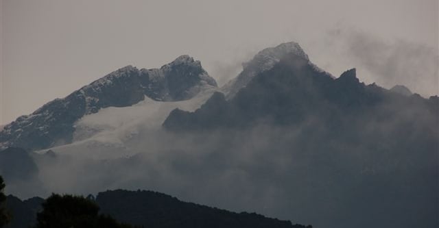
Mount Stanley is the central massif of the Rwenzori Mountains; its highest summit is Margherita Peak (commonly cited at 5,109 m). The Stanley massif straddles the Uganda–Democratic Republic of the Congo border and lies within the Rwenzori Mountains National Park (Uganda).
Mount Stanley is a massif in the Rwenzori Mountains on the Uganda–Democratic Republic of the Congo border. Its highest summit is Margherita Peak at 5,109 m (16,762–16,763 ft). The mountain and Margherita Peak lie within the Rwenzori Mountains National Park (managed by Uganda Wildlife Authority) and are part of the Rwenzori range (the 'Mountains of the Moon').
Mount Stanley is the highest massif in the Rwenzori range; its highest summit, Margherita Peak, is listed at 5,109 m (16,763 ft) and lies on the Uganda–DR Congo border within Rwenzori Mountains National Park (Western Region, Kasese area). Coordinate point records for the summit (Margherita Peak / Mount Stanley) are available from OpenStreetMap (lat 0.3856068, lon 29.8729544). ([ugandawildlife.org](https://ugandawildlife.org/national-parks/rwenzori-mountains/?utm_source=openai))
Mount Stanley is a massif in the Rwenzori Mountains on the Uganda–Democratic Republic of the Congo border; its highest summit (Margherita Peak) is cited at ~5,109 m (commonly quoted) and is the highest point of the Rwenzori range and one of Africa’s highest peaks. Summit coordinates are given in published peak databases (decimal ~0.385466° N, 29.873188° E). Mount Stanley/Margherita Peak lies within the Rwenzori Mountains National Park (managed by UWA) and is a technical, multi-day mountaineering objective with glacier travel on the upper slopes. (Sources: UNESCO; Uganda Wildlife Authority; Peakbagger; climbing/park guides).
Main Uganda-side trailhead for the Central Circuit and the normal start for hut-based Rwenzori expeditions.
Upper basin staging point before moving to summit camp.
First mountain camp on the Rwenzori approach.
Summit staging camp for the Margherita Peak attempt.
Higher valley camp used on the acclimatisation progression toward the central basin.
Lower camp reached after the Margherita Peak summit day.